ABOUT
MOZAMBIQUE
GENERAL
Government
type
Mozambique is a Republic.
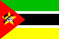
Flag
description
Three equal horizontal bands of green (top), black, and yellow
with a red isosceles triangle based on the hoist side; the
black band is edged in white; centered in the triangle is
a yellow five-pointed star bearing a crossed rifle and hoe
in black superimposed on an open white book.
Population
The population of Mozambique is approximately 19.7 million.
Area
The land area of Mozambique is 801 590 sq. km (slightly less
than twice the size of California) land: 784,090 sq km water:
17,500 sq km. The country is located in Southern Africa, bordering
the Mozambique Channel, between South Africa and Tanzania.
Geographic coordinates: 18 15 5, 35 00 E
The
total border is 4,571 km, of which coastline is 2,470 km.
The country shares borders with Malawi, South Africa, Swaziland,
Tanzania, Zambia and Zimbabwe.
Maritime claims: exclusive economic zone: 200 nm territorial
sea: 12 nm
The
capital is Maputo. There are 10 provinces - Cabo Delgado,
Gaza, Inhambane, Manica, Maputo, Nampula, Niassa, Sofala,
Tete, Zambezia
The
climate is tropical to subtropical
The
terrain is mostly coastal lowlands, uplands in centre, high
plateaus in northwest, mountains in west
Elevation
extremes - the lowest point is the Indian Ocean 0 m; the highest
point is Monte Binga 2,436 m
Natural
resources include coal, titanium, natural gas, hydropower
Land
use:
arable land: 4%
permanent crops: 0%
permanent pastures: 56%
forests and woodland: 18%
other: 22% (1993 est.)
Irrigated land: 1,180 sq km (1993 est.)
Per
Capita Income
The GOP per capita is approximately US$ 935
Language
The official language is Portuguese
Back
to top
Geography
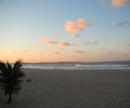
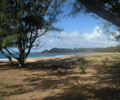
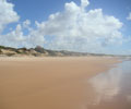
Mozambique is dominated by its three thousand-kilometre coastline.
Savannah and dense woodlands and forests largely cover the
interior of the country.
The western border with Zimbabwe is demarcated by the range
of mountains stretching from Chimanimani in the south to the
highlands of Nyanga in the north.
The
Limpopo River enters Mozambique south of these mountains and
crosses the flat coastal plains of thick bush to empty into
the blue seas at Xai Xai, 200 kilometres north of Maputo.
This area has been earmarked for inclusion into the Transfrontier
Park which is being established and which will include the
Kruger National Park in South Africa and Gonarezhou National
Park in Zimbabwe.
Maputo
is recovering some of its former elegance and style and five
star international hotels have been fully restored to their
former glory. The Maputo experience is a gastronomic delight
with great seafood and succulent LM (Lorenzo Marques) prawns
of legendary size and quality. The island of Inhaca, thirty
kilometres from the city over the Bay of Maputo, is a tropical
paradise of white beaches, coral reefs and palm trees.
The
islands of the Bazaruto Archipelago are an idyllic tropical
paradise surrounded by crystal clear, aquamarine seas and
spectacular coral reefs just offshore from the resort centre
of Vilankulo. The country is divided by the Zambezi River,
which flows through the Central Provinces of Tete; Sofala
and Zambezia and has proved a formidable barrier to the development
of the northern provinces of the country.
Above
Tete the Zambezi is contained by one of the largest dams in
Africa, Lake Cahora Bassa. The Zambezi River empties into
the Indian Ocean through an enormous estuarine area north
of Mozambique’s second city of Beira.
From
Beira north across the Zambezi River to Quelimane, Nampula
and Mozambique Island little sign of rehabilitation of the
war-ravaged infrastructure is evident. Bridges are down, roads
are in very poor condition and the large towns of this region
show evidence of serious neglect and isolation from the outside
world.
The
region is however scenically spectacular and for the traveller
prepared to rough it, a journey through this part of Mozambique
would be an adventure unlikely to be forgotten. Spectacular
Mozambique Island has been declared a world heritage site
and the castle of St Sebastian and St Pauls Palace, amongst
other architectural gems, are quite breathtaking and fortunately
being restored.
North
from Mozambique Island and Nampula leads to the spectacular
small city of Pemba built on the spine of a peninsula overlooking
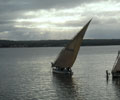
an enormous natural harbour. Traditional Arab sailing boats
known as Dhows leave from Pemba to exotic destinations within
the Quirimba Archipelago such as Ibo and to destinations further
north such as Mafia Island, Dar-es Salaam and Zanzibar. Ibo
is a sizeable former Portuguese town on Ibo Island, it boasts
three forts, traditional silversmiths, ancient crumbling architecture,
coral reefs and a lifestyle untouched by the outside world.
Mozambique’s northern frontier with Tanzania follows
the remote and isolated Ruvuma River through a vast wilderness
of savannah and forests.
Directly
west from Pemba across the top of the country, Mozambique’s
western border touches Lago Niassa or as it is better known,
Lake Malawi. Unlike the Malawian shoreline, the shoreline
is completely undeveloped and difficult to access. If you
get there the view across ‘The Lake of Stars”
with the hills behind you rising to the highlands around Lichinga
is majestic and overwhelming with the excitement and mystery
of Africa.
Mozambique
is divided by at least 25 main rivers, all of which flow to
the Indian Ocean. The largest and most historically significant
is the Zambezi, whose 820km Mozambican section is navigable
for 460km. Flowing from eastern Angola, the Zambezi provides
access to the interior of Africa from the eastern coast. Other
important rivers are the Limpopo in the south, the Save in
the middle and the Lugfenda in the north.
In
the river valleys and deltas, the soil is rich and fertile,
but southern and central Mozambique has poor and sandy soil,
and parts of the interior is dry.
Back
to top
The
Zambezi River
The Zambezi, meaning “Great River” begins in the
central African plateau and either forms the boundaries of
enters the countries of Angola, Zambia, Namibia, Botswana,
Mozambique and Zimbabwe.
The
Zambezi originates in Northwestern Zambia, formerly Rhodesia,
and flows through Angola, Botswana, Zimbabwe, and finally
to Mozambique. Here it empties into the Indian Ocean 1600
miles from its headwaters.
Located
in south-central Africa, the Zambezi River and its tributaries
form the fourth largest river basin on the continent. The
Zambezi, meaning ‘Great River’ begins in the central
African plateau and either forms the boundaries or enters
the countries of Angola, Zambia, Namibia, Botswana, Mozambique
and Zimbabwe.
The
Zambezi River’s route from Kariba in Zimbabwe down to
Kanyemba near the border with Mozambique is regarded as the
best canoe safari destination in Africa. The Zambezi is the
geographical boundary between Zambia and Zimbabwe and offers
the ideal combination of unspoiled wilderness and diverse
habitats that support a massive wildlife population in Mana
Pools National Park and the Lower Zambezi National Park on
the Zimbabwean and Zambia shorelines.
The
Zambezi River is classified as a high volume; pool-drop river
i.e. there is little exposed rock either in the rapids or
the pools below the rapids. The distance between rapids varies
from 100 metres to 2 kms. The Gorge itself is approximately
400 ft deep at the put-in point and 750 ft at the take out
point. The river drops about 400 ft over the 24 km covered
in the one-day raft trip and the depth of the river can reach
200 ft.
The Zambezi River is one of Africa’s rivers of life.
Throughout the 1653 miles
(2660 km) of its course, it gives water to humans who drink
it and use it for crop growing, who capture its energy for
hydro-electric power, who fish for food, and who enjoy its
environments for recreation. It also supports an abundant
wealth of aquatic and animal life - some are unique to Africa.
The
most important lake is the navigable Lake Niassa (Lake Malawi).
Lake Malawi provides one the opportunity to forget about the
hurried passing of time. Still reasonably untouched by the
contemporary world, the lake is an immense quintessence of
a thousand picture postcards. Lake Malawi is the ninth largest
lake in the world. It is 560km, 80km wide and 700m deep and
forms most of the eastern border between Malawi and Mozambique.
Back
to top
Economy
Mozambique is one of the poorest countries in the world with
an economy almost completely eliminated by years of mismanagement
and civil war. In recent years however the Frelimo Government
has adopted free enterprise principles and the economy has
grown significantly off a very low base. Financial growth
has however been severely curtailed by the flooding of 2000
and 2001 which destroyed recently reconstructed roads and
other communication links.
Agricultural
activity is once again expanding and major advances made in
the rehabilitation of the cashew; tea and copra industries.
Commercial fishing is also beginning to have a positive impact
on the economy of Mozambique. Tourism facilities are being
revived and the beneficial effect of developing the tourist
industry is being realised.
Before
the peace accord of October 1992, Mozambique’s economy
was
devastated by a protracted civil war and socialist mismanagement.
In 1994, it ranked as one of the poorest countries in the
world. Since then, Mozambique has undertaken a series of economic
reforms. Almost all aspects of the economy have been liberalized
to some extent. More than 900 state enterprises have been
privatized. Pending are tax and much needed commercial code
reform, as well as greater private sector involvement in the
transportation, telecommunications, and energy sectors.
Since
1996, inflation has been low and foreign exchange rates stable.
Albeit from a small base, Mozambique’s economy grew
at an annual 10% rate in 1997-99, one of the highest growth
rates in the world. Still, the country depends on foreign
assistance to balance the budget and to pay for a trade imbalance
in which imports outnumber exports by five to one or more.
The
medium-term outlook for the country looks bright, as trade
and transportation links to South Africa and the rest of the
region are expected to improve and sizable foreign investments
materialize. Among these investments are metal production
(aluminum, steel), natural gas, power generation, agriculture
(cotton, sugar), fishing, timber, and transportation services.
Additional exports in these areas should bring in needed foreign
exchange. In addition, Mozambique is on track to receive a
formal cancellation of a large portion of its external debt
through a World Bank initiative.
Back
to top
Climate
Mozambique is essentially a hot country as it is mostly situated
at low elevations and almost entirely within the tropics.
The hot rainy season is from November to March and the dry
winter months are cooler but still quite hot during the day;
especially along the northern coast.
Average maximum temperatures in centigrade are as follows:
|
|
Summer
|
Winter |
|
|
Oct-Mar
|
May-Aug |
| |
|
|
| Xai
Xai |
30 |
20 |
| Maputo |
30 |
19 |
| Vilankulo
|
30 |
20 |
| Chimoio
|
25 |
18 |
| Beira
|
30 |
20 |
| Que
|
30 |
26 |
| Nampula |
35 |
20 |
| Pemba |
30 |
25 |
| Lichinga |
25 |
15 |
| Tete
|
40 |
25 |
There
are two main seasons, one wet and the other dry, divide the
climatic year. The wet season, from November to March, has
a monthly average
temperature of between 26.6°C and 29.4°C (80°F
and 85°F), with cooler temperatures in the interior uplands.
The dry season lasts from April to October and has June and
July temperatures averaging 18.4° to 20°C (65°
- 68°F). The average annual rainfall is greatest (about
56 inches) over the western hills and the central areas, and
lowest in the Zambezi lowlands averaging 16 to 32 inches.
Back
to top
Transportation
Mozambique has some 200 airports, of which 22 are tarred.
There are 30,400 km of highways, of which 5 685 km is paved
There are about 3,750 km of navigable waterways
Ports and harbours include Beira, Inharnbane, Maputo, Macala,
Pemba and Quelimane
Plant
and animal life
Although Mozambique retains some dense forestlands in the
north-central interior and on the Chimoio Plateau, most of
the north and east-central areas are open forest. In the south
the open forest of the east becomes brush and savanna grassland
to the west.
The
largest forest reserves are on the Chimoio Plateau west and
southwest of Beira and in the northern interior south of the
Lürio River. Mozambique maintains four national parks
in the central and southern areas, Gorongosa, Zinave, Bazaruto,
and Banhine.
Wildlife
populations include water Buffalo, Elephant, Warthog, Leopard,
Baboon, Giraffe, Zebra, Antelope, Lion, and numerous species
of ungulate and cat. Crocodiles and Hippopotamus are still
found in slow-moving waterways. Snakes, including impressive
pythons and dangerous puff adders, cobras, and vipers, are
found throughout the territory.
Flamingos,
cranes, storks, herons, pelicans, ibis, and other tropical
water birds exist throughout Mozambique but are more numerous
in the moister areas of the northeast. Scavengers include
crows, vultures, and buzzards, and game birds include guinea
fowl, partridge, quail, and a range of geese and ducks.
Game reservations and national hunting areas are located largely
in the central and southern areas, with the exception of the
important Niassa reserve on the Tanzanian border and the Gilé
reserve southwest of Nampula. The largest game areas are just
south of the Zambezi bordering the Chimoio highlands. The
nation’s five hunting reservations are Niassa, Gilé,
Marromeu, Pomene, and Maputo.
Back
to top
National
Parks and Reserves
Various national parks possess the conditions suitable for
safaris and other
similar activities. Outstanding because of their importance
are Gorongosa (Sofala), Zinave (Inhambane/Gaza), Banhine (Gaza)
and Bazaruto (Inhambane). There are also several hunting reserves,
such as the Elephant Reserve (Maputo), Pomene (Inhambane),
Gile (Zambezia), Marromeu (Sofala), and Niassa (Niassa), as
well as other designated hunting areas scattered throughout
the country.
The
Gorongosa National Park (3,770 sq. km), once regarded as among
the richest in Southern Africa, is currently benefiting from
rehabilitation work on its infrastructure and restocking of
the animal population. The Bazaruto National Park, located
on the island of the same name in Inhambane province, is the
only marine park and constitutes an important tourist attraction
due to the enormous possibilities it offers for diving and
underwater fishing. |